|
PHYSIOGRAPHY:
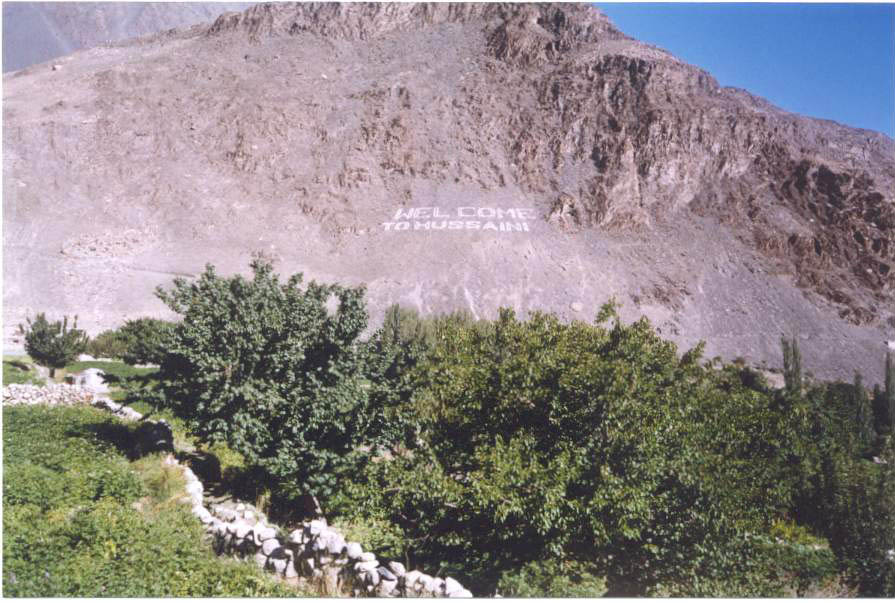
Hussaini is located in the center of the Karakoram Range, surrounded by high mountains having the heights of more than 7000 meters. Most of the peaks, remain snow covered throughout the year. Shishper (7611 m) is the highest peak of the study area. The rock exposed in the area is mainly Slate i.e. metamorphic. |
|
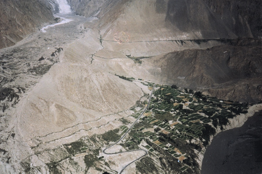
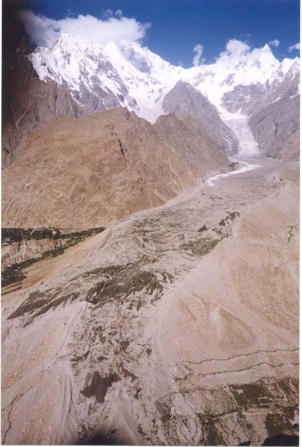
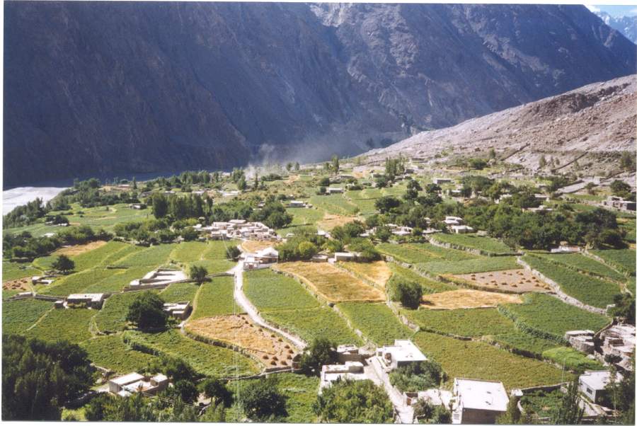
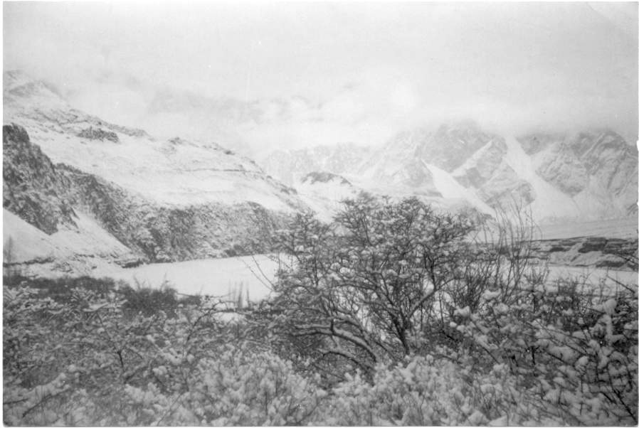
A view of Hussaini village, KKH, Hussaini Glacier and Hunza River
|
HUSSAINI GLACIER
The glacier is situated in the west of the village and moves from northeast to southwest towards KKH and Hunza River.
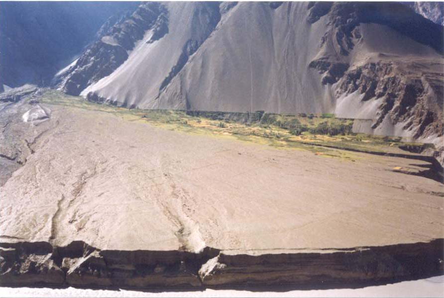
It is approximately 17.5 km long with a headwall at up to 5950 m between two peaks that rise to 7331 m and 7613 m. The glacier descends from 5500 m with a mean slop of 14.6%. Its terminus in 1980 was separated into two parts, a northern tongue and an irregular southern margin, which could be further sub-divided into two small lobes separated a melt water portal. It appears to have this general form since at least 1996. However, its heavily crevassed snout and numerous small caves testify to large scale melt water production. These melt water flows frequently change in volume and exit position. The changing pattern of debris production and redistribution on the steeply sloping out wash cone pose a major hazard to the Karakoram highway and a 200 m. section of road was actually destroyed by these means during August 1980.
The main valley section of the glacier is enclosed between steep high moraines, the black debris-laden ice smothered by large quantities of superficial moraine. Ogives and rock fall crevasse pattern are well developed, and there are extremely steep ice falls towards the head. The twin lobes of the snout appear to have an extension in the ice topography for several km up the glacier, the two ice ridges being separated by the pronounced central depression.
The recent history of the glacier is poorly known since most visitors have merely confined themselves to discussing the difficulties of crossing the out wash spreads and only give crude estimates of the distance of the snout from the Hunza river. Although the precise pattern of movement is unknown, reliable records do exist which indicates that the snout position has fluctuated by 625 m during the period 1885-1980, with a notable advance between 1913 and 1925 and a further small advance between 1966 and 1978. This again repeats the general pattern observed for the Minapin and Hasanabad glacier, although the advance early in this century appears to lag by some ten to fifteen years. It is significant that the minor advance of the early 1970s appears on all three records. The movements, therefore, appear to be periodic but in this case there is no overall secular retreat. There has been no record of blocking of the Hunza river and no evidence either of massive retreat. Instead, the snout seems to have experienced limited oscillation around its present positionp.
|
|
|
|
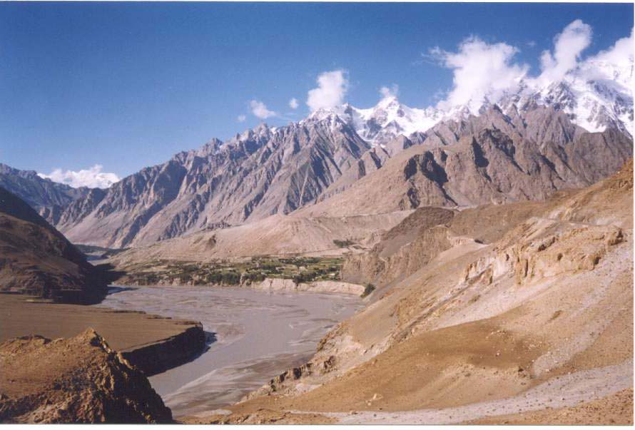
According to this field survey, the distance between the snout and the KKH is 301 meters (990 feet)l. It is advancing for last many years. It can be predicted that if the same situation remains in future, it may be reach at KKH within between 10 to 15 years.
It is the only source of water supply for irrigation and also for drinking in summer season. The whole village is depending on this glacier, locally known as "Sisuni Yaz", but with an error or otherwise, this glacier is shown and advertised on the maps by Ghulkin glacier.
|
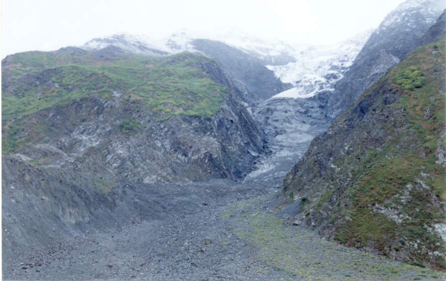
Southern snout of Hussaini Glacier.
|
|
|
|
ZARABOD GLACIER
It is a small glacier between Zarabod and Khuramobod. Though it is not a glacier in geomorphic term rather is a depression called cirque. The stream originated from that glacier irrigates the land of Zarabod. This stream is shared between Zarabod (Hussaini) and Khuramabd (Passu). The stream water is shared by Zarabod, and Khuramobod on alternate day. |
RIVER
The rivers of the valleys of Khunzhrav (Khunjarab), Misgar, Chipursan, and Shimshal which include the water of various famous glaciers Batura, Verzhrav, Khurdopin, Yazghel, Passu, Hussaini and Gulmit passing through Central Hunza and Nagar to Gilgit. Thus, this river is named as the Hunza River that flows from the north to the south.
|
|
|
|
TERRACES
HUSSAINI
Hussaini is located on a glacial landform e.g., lateral moraine, formed by Hussaini glacier. The moraine is exposed of huge boulders, gravel, pebbles, and sandy soil with a gentle slope.
Hussaini spreads upward from the bank of the Hunza River and reaches up to a considerable elevation along the lateral moraine of Hussaini glacier. In the south the snout of glacier and the glacial stream separates Hussaini from Ghulkin. In the northern part, the boundary of Hussaini, it ends at Rukhn kor with Passu.
According to the folklore, Hussaini was a big village of Gojal, but unfortunately Shimshal flood eroded it many times in early 1960s. It is said that the distance between Hussaini and Zarabod was very close, people used to throw stone to Zarabod by their left hands (about 60 meter), but now, according to this field survey the distance between these two villages (Hussaini & Zarabod) is 1 kilometer. Shimshal flood occurred periodically every twenty years, the last flood, which was very disastrous, came in 1960 and continued up-to 1963. This flood happened as a result of glacial hazard. Two glaciers merged Khurdopin and Yazghel with each other and blocked the stream of other glacier (Verzrav), which made a big dam and when it was opened, it eroded a large area of Passu, Hussaini, and Gulmit.
|
ZARABOD
Zarabod is located to the east of Hussaini at the eastern-bank of Hunza River. It is an alluvial fan, formed by Zarabod-Khuramobod stream. It also has a gentle slope. It starts from the eastern bank of Hunza River and goes up slowly and gradually and reaches at the foot of Zarabod glacier, which is locally called as "Zwor". The stream has naturally separated Zarabod from Khuramobod (Passu).
Chramn is the old settlement of Zarabod, where inhabitants of Hussaini live together in a local house. From this place they used to go their fields to work.
Zarabod has the following areas with different local names, Shah Khunzo, Qash Sar, Ben, Chramn, Put Dasht, Yinaghn, Hussneben, and Dasht.
Dasht means barren land, which is located to the north of Zarabod. The government magistracy (tehseel) and the Aga Khan Arbitration and Reconciliation board for the concerned region divided this barren land (Dasht) among the villagers in May 1998: this division of land was 23 kanal per households -numbering 72.
Zarabod has no jeep-able road, and it has connected with Hussaini through a suspension bridge (635 feet) called "Duet" constructed in 1970. Both Zarabod and Suspension Bridge are too attractive in tourism perspective.
|
|
|
|
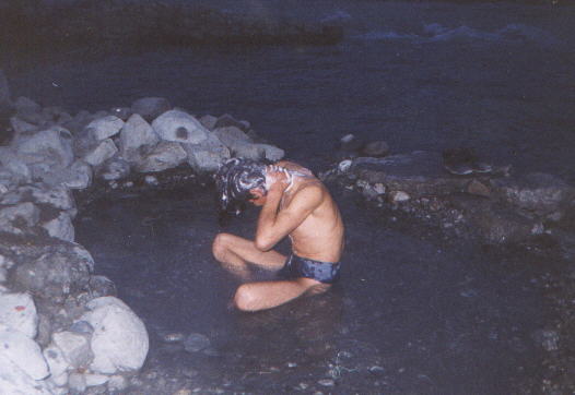
HOT SPRING
Nature has gifted a hot spring (45*c) to this village, which springs out at the left bank of Hunza River. According to laboratory test, the water is drinkable. It has been using for bath, when the volume of water in Hunza River becomes less and the level down from the spring source in winter season, but the area is covered by river in summer. |
CLIMATE
The average weather condition of a sizable area of the Earth's surface over a period of time is called climatet. Weather is the atmospheric conditions prevailing at a specific time over a short period, from hour to hour, or from day to day.
The climate in Hussaini can be divided into four seasons, i.e. winter, spring, summer, and autumn season.
|
|
|
|
WINTER SEASON
The winter is cold and chilly. It starts from 15th November and remains up to the end of March. From December up-to the end of February the temperature remains below 00 C. In winter Hussaini is sometimes covered with snow. Due to nearness of the glaciers, it has been noted, it receives much snowfall as compared to other neighbor villages. An annual average snowfall is 8 to 10 inches, but in January 2000, the snowfall was 14"(own survey in 2000), which is unusual for the last so many years. The snowfall is due to the western depression. Human activities become limited in this season. The people have to confine themselves to indoor activities: for example, cottage industry.
During these months the villagers also become busy in performing marriage ceremonies. The other activities for male are hunting, making Hunzai caps, Hunzai carpet called “Plosâ€ÂÂ. Female folk weave and spin. They make caps table-clothes and handkerchiefs. They also make gloves, Chogha (cloak), mufflers, socks and many other items.
SPRING SEASON
It starts from April to the end of May. A considerable amount of rain is obtained
in spring. All the fruit trees like apple, apricots, pears etc blossom in this season.
Agricultural activities are practiced in this season, e.g., wheat is sown, and
potatoes are also grown in this season. Almost all sort of plantation is carried out during this season. SUMMER SEASON
Three months, from June to August, is the summer season. These are the driest months of the year. The average temperature is low as compared to the plains of the country. These are also the busiest months for the people. All sort of agricultural activities, e.g., harvesting, and threshing of wheat, pasturing of cattle and drying process of apricots etc. is carried out in these months.
AUTUMN SEASON
From 1st September up-to 15th November is the autumn months. Rain is also received this season. Fodder for cattle and firewood is stored.
|
VEGETATION
Climatic conditions and soil types determine vegetation comprises forests, shrubs, and grasses. The climate is dry for forest. Soil formation on the hill slopes is a necessary condition for vegetation growth. But because of human practices in this area, the soil is being eroded rather than of soil development. There are two main types of forest, irrigated and un-irrigated or natural forest.
IRRIGATED PLANTED FOREST
This very important forest comprising of different species, e.g., apricot, walnut, almonds, grapes, pear, peaches, apple, poplar etc. Poplar trees are mainly used as a timber and firewood. Mulberry and walnut trees are used for high quality furniture. In accordance with this survey in Hussaini, every household has 30 to 500 (mostly fruit) trees, because the villagers have common tradition of planting forest.
|
|
|
|
UN-IRRIGATED FOREST OR NATURAL FOREST
This forest is found on the hill slopes in isolated patches. It supplies firewood to the villagers. Important species on the upper most reaches of the village are juniper, salix, epheda, with flexible and adopted to snow pressure. Berry fruits are also found.
Most upper reaches of the mountains have betula nana, salix, juniper, ephedra, vibe mum, loniera and ribber.
Borit-e- Ruy, Ishkor Sar, Ghaypar, Zarabod Roy and Batura are the main patches of these species. The main patches of natural forest and grazing points in Batura South are Jang-e-Kerch, Stugh Dhur, Baj Yarz and Nawgarch.
|
SOIL
Soil in Hussaini is fertile sandy, and loamy on terraced fields. On the steep slopes, it is easily washed down by torrential rainfall, mass wasting and erosion, is the common geomorphic process in the area.
|
|
|